Watermark.
Lima BOSC
Switch site 35 sites · 10 basins2 states Group by
OH Ohio 34
BOSC BOSC Lima Ottawa River · Lima, OH Building Under construction #1261 URB Urbana Mad River · Great Miami Live Investigating #1263 DEF Defiance Maumee mainstem Queued Investigating #1264 FIN Findlay Blanchard River Queued Investigating #1265 TOL Toledo Lucas Co WRRF Queued Investigating #1266 VWT Van Wert Town Creek · Little Auglaize Queued Investigating #1267 BRY Bryan Prairie Creek · Tiffin River Queued Investigating #1268 OTW Ottawa Blanchard River (lower) Queued Investigating #1269 SPR Springfield Mad River · Great Miami Queued Investigating #1270 XEN Xenia Little Miami Queued Investigating #1271 WPA Dayton · WPAFB Mad River · Great Miami Queued Investigating #1272 HAM Hamilton · Middletown Great Miami (lower) Queued Investigating #1273 TRP Troy · Piqua Great Miami (upper) Queued Investigating #1274 SID Sidney Great Miami · headwaters Queued Investigating #1275 GRV Greenville · Darke Co Stillwater · basin divide Queued Investigating #1276 WIL Wilmington Todd Fork · Little Miami Queued Investigating #1277 WUN West Union · Adams Co Ohio Brush Creek · Ohio River Queued Investigating #1278 NAL New Albany · Licking Scioto ↔ Muskingum divide Tracking Investigating #1279 COL Columbus Scioto · Olentangy Tracking Investigating #1280 CSH Coshocton Tuscarawas + Walhonding Tracking Investigating #1281 PIK Piketon Scioto River · PORTS Tracking Investigating #1282 SAN Sandusky · Perkins Twp Sandusky Bay · Lake Erie Tracking Investigating #1283 NWK Newark Licking River Tracking Investigating #1284 ZAN Zanesville Muskingum mainstem Tracking Investigating #1285 FRE Fremont · Clyde Lower Sandusky Tracking Investigating #1286 TIF Tiffin Sandusky (mid) Tracking Investigating #1287 BUC Bucyrus Sandusky headwaters Tracking Investigating #1288 CLE Cleveland Lower Cuyahoga Tracking Investigating #1289 AKR Akron Upper Cuyahoga · CVNP Tracking Investigating #1290 LRD Lordstown · Warren Upper Mahoning Tracking Investigating #1291 YNG Youngstown Mahoning mainstem Tracking Investigating #1292 LAN Lancaster Upper Hocking Tracking Investigating #1293 ATH Athens Lower Hocking Tracking Investigating #1294 LOG Logan Hocking Hills Tracking Investigating #1295
MAU Maumee Basin 8 sites
2MI The Two Miamis 9 sites
SE Southeastern Basins 10 sites
NE Northeast Basins 8 sites
Each site is a section of the Watermark platform — pivoted by basinstate. Live & building sites open; queued and tracking sites route to their coming-soon / watch page.
Switch site 35 sites · 10 basins2 states 35 open Group by

Each site is one Watermark investigation. The page color says what opens; the campus line is the build on the ground — two different clocks.

OH Ohio 34
BOSC BOSC Lima Ottawa River · Lima, OH Draft Under construction #1261 URB Urbana Mad River · Great Miami Open Investigating #1263 DEF Defiance Maumee mainstem Queued Investigating #1264 FIN Findlay Blanchard River Queued Investigating #1265 TOL Toledo Lucas Co WRRF Queued Investigating #1266 VWT Van Wert Town Creek · Little Auglaize Queued Investigating #1267 BRY Bryan Prairie Creek · Tiffin River Queued Investigating #1268 OTW Ottawa Blanchard River (lower) Queued Investigating #1269 SPR Springfield Mad River · Great Miami Queued Investigating #1270 XEN Xenia Little Miami Queued Investigating #1271 WPA Dayton · WPAFB Mad River · Great Miami Queued Investigating #1272 HAM Hamilton · Middletown Great Miami (lower) Queued Investigating #1273 TRP Troy · Piqua Great Miami (upper) Queued Investigating #1274 SID Sidney Great Miami · headwaters Queued Investigating #1275 GRV Greenville · Darke Co Stillwater · basin divide Queued Investigating #1276 WIL Wilmington Todd Fork · Little Miami Queued Investigating #1277 WUN West Union · Adams Co Ohio Brush Creek · Ohio River Queued Investigating #1278 NAL New Albany · Licking Scioto ↔ Muskingum divide Watching Investigating #1279 COL Columbus Scioto · Olentangy Watching Investigating #1280 CSH Coshocton Tuscarawas + Walhonding Watching Investigating #1281 PIK Piketon Scioto River · PORTS Watching Investigating #1282 SAN Sandusky · Perkins Twp Sandusky Bay · Lake Erie Watching Investigating #1283 NWK Newark Licking River Watching Investigating #1284 ZAN Zanesville Muskingum mainstem Watching Investigating #1285 FRE Fremont · Clyde Lower Sandusky Watching Investigating #1286 TIF Tiffin Sandusky (mid) Watching Investigating #1287 BUC Bucyrus Sandusky headwaters Watching Investigating #1288 CLE Cleveland Lower Cuyahoga Watching Investigating #1289 AKR Akron Upper Cuyahoga · CVNP Watching Investigating #1290 LRD Lordstown · Warren Upper Mahoning Watching Investigating #1291 YNG Youngstown Mahoning mainstem Watching Investigating #1292 LAN Lancaster Upper Hocking Watching Investigating #1293 ATH Athens Lower Hocking Watching Investigating #1294 LOG Logan Hocking Hills Watching Investigating #1295
MAU Maumee Basin 8 sites
2MI The Two Miamis 9 sites
SE Southeastern Basins 10 sites
NE Northeast Basins 8 sites
The page — what opens on Watermark Open · Draftfull record Queued · Watchingpreview page Restrictedrequest access
The campus — the build on the ground Investigating Confirmed Under construction Operational
Building

← Records

The record · how to read it

How to read any record

Every record on this site — a contractor's cost estimate, an air permit, a water-discharge screen — is read the same five ways. Learn the grammar once and you can check any figure on the site yourself. Nothing below is summarized for you: each is a real record, read from the published bundle, with its evidence class on every line.

The five beats

One transformation — source → structured read → meaning → verify → connect — applied to whatever the record happens to be:

The source — the artifact and its provenance, messiness left visible
What we read — the structured extraction, each value's confidence shown
What it reveals — plain meaning, with the one load-bearing number called out
How to check it — the evidence tag and a link to verify it at the source
Where it connects — doors into the rest of the library

The evidence classes

Beat ④ hangs on one vocabulary. Every figure carries its evidence class — read it as a confidence signal, not decoration:

Evidence tags

[verified]
Read from a cited record or a live source — confirmed and reproducible.
[inference]
A labelled reading or derivation from cited inputs — reasoning, not a record.
[reference]
An outside published specification or dataset — authoritative, but not a record about this site.
[open]
Withheld, unresolved, or not yet checked — a question, not a verdict.

One grammar, three record types

Switch between three genuinely different records below. The artifact changes; the five beats don't. Each is a real extraction — the in the published bundle badge marks the ones whose figures are read live from the same row the library renders.

Record type
Record Teardown

Opinion of Probable Cost

Tetra Tech · BOSC Roadwork · filed 2025-07-11
● in the published bundle
Scanned PDF · degraded OCR
① The source
PRR-01-bundle.pdf
SCAN
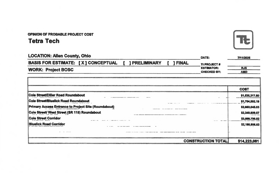
Tetra Tech Opinion of Probable Project Cost — summary sheet: six corridor roundabout line items with a CONSTRUCTION TOTAL of $14,223,081.
pp. 317–328 · Public Records Request 01 · summary sheet · sheet 1 of 11
The summary sheet is shown as a committed crop of the source scan (regenerated by scripts/render_walk_crops.py); the full 11-sheet exhibit is available on request.
② What we read from it
Program total
$14,223,081
Sub-estimates
6 corridors
Contingency
25%
Largest — Cole St
$3,899,800
Drainage line
$1,068,530 · 7.5%
Design-storm basis
~ not cited
Detention shown
~ none
● figures read live from the published record · ~ markers preserved as approximate
③ What it reveals

The public's road package is priced to the dollar — $14,223,081 — yet drainage is just 7.5% of it, the only one of six items detailed, with no design-storm basis and no detention shown. A number that precise on a scope that thin is the tell.

Record Teardown

Air Permit-to-Install P0138965

Ohio EPA · Division of Air Pollution Control · FINAL, issued 2026-05-28
● in the published bundle
Issued permit · text-native
① The source

Bytes not pulled locally (Git-LFS pointer) — available on request.

Download · Open in a new tab

issued PTI + 64-item Response to Comments · Ohio EPA · Air permits (eDoc 4132514)
The 66-page issued eDocument is committed as provenance; engine make/model/size is redacted in the source itself as trade secret.
② What we read from it
Emissions units
115 · P001–P115
Data-hall gensets
114 · 3 groups of 38
Cooling towers
36 · 3 groups of 12
NOx cap
235.62 tpy
CO cap
96.06 tpy
Per-engine power (ekW)
~ redacted · CBI
Backup total
~313 MW · draft only
● figures read live from the published record · ~ markers preserved as approximate
③ What it reveals

The permit fixes the plant's shape exactly — three matched groups of generators and cooling towers, 114 data-hall gensets — yet locks the one number that sets its true scale, per-engine power, as a trade secret. The ~313 MW everyone cites is the draft public-notice figure; the issued permit will not confirm it.

④ How to check it
[open]per-engine ekW · trade secret
ekW · REDACTED · CBI Why won't the permit say how big it is?
the lock

Engine make / model / size — and so the per-engine ekW that sets the plant's true electrical scale — is claimed as a trade secret and withheld from the issued permit.

The permit fixes the plant's shape exactly — 114 data-hall gensets and 36 cooling towers in three matched groups — yet locks the one number that would let you compute its real backup capacity. The ~313 MW everyone cites is the draft public-notice figure; the issued permit will not confirm it. The scale is set; the proof is withheld.

Record Teardown

NPDES fact sheet — the 7Q10 screen

Ohio EPA · American II WWTP · permit 2PH00006 (Dug Run)
● in the published bundle
Permit fact sheet · text-native
① The source
facility_name
Allen County American II Wastewater Treatment Plant (WWTP)
permit_no
2PH00006*LD
permit_action
renewal
applicant
Allen County Board of Commissioners, 3230 North Cole Street, Lima, OH 45801
application_no
OH0037338
public_notice_no
211697
public_notice_date
2025-04-28

View the source document →

Stream Flows table · Ohio EPA · NPDES fact sheets
7Q10 values are read from the Ohio EPA fact sheets committed in the corpus; the fact-sheet PDFs are available on request.
② What we read from it
Receiving water
Dug Run · impaired
7Q10 design low flow
0.78 cfs
1Q10 (driest week)
0.6 cfs
Summer 30Q10
0.96 cfs
Stated acute dilution
1.3 : 1
Ottawa mainstem 7Q10
0.2 cfs
Ottawa 1Q10 (driest week)
0 cfs · nearly dry
● figures read live from the published record · ~ markers preserved as approximate
③ What it reveals

Ohio EPA sizes every discharge against the stream's design low flow — and the Ottawa this project discharges into runs at just 0.2 cfs, dropping to zero in the driest weeks. The tributaries are worse: American II's own fact sheet states a dilution of barely 1.3 to 1. The receiving water is near-undiluted before this project adds a drop.

④ How to check it
[verified]fact-sheet 7Q10

A dollar total, a redacted emissions table, a low-flow water screen — three filings, one reading. Open the full record library to read any of them the same way, or each teardown's verify link to land on the exact source.